

I help institutions and individuals organize, understand, and share observations and ideas about places; to understand how places work in their context; so that people can more effectively collaborate, make more informed decisions, and appreciate the quality of places as they are, as they were, as they change or may be changed. I have trademarked a short phrase that captures this mission: cultivating spatial intelligence. Let's take observations and ideas from multiple points of view and make them stick together in useful ways!
For more information email paulbcote@gmail.com
2026 News
- New CDASH 5 Release is now Mobile! Check out the CDASH 5 Sneak Preview
- The CDASH Batch Digester is a desktop tool for creating Archival Ingest Packages making CDASH a complete Open Archival Information System. See the documentation.
- The Cambridge Repository / Catalog of Open Format Building Models and City Model Tiles has been updated. Visit the downloads page. See the 3D Model Generation Video.
2025 News
- The Cambridge Digital Architectural Survey and History (CDASH) is now Live with a new URL. Change your links to CDASH.CambridgeMa.gov. Now with over 75,000 documents related to 15,000 cambridge buildings and open spaces, we are about 95% finished with the initial loading process.
- See the latest CDASH Slideshow presented at the Boston Area Digital Humanities and Research Pedagogy Conference.
- Closer to home: a proposal to develop a large pharmaceutical R&D facility adjacent to the pbcGIS home office created an opportunity to combine our public-access city model project with some historical documents from CDASH. This analysis of the impacts of the developer's proposals on the historic schoolyard, Ahern Field, has been instrumental in negotiations between the East Cambridge neighborhood and the developer.
2024 News
The cities of Boston and Cambridge are now sharing their city model assets in open formats repository and catalog based on our citySchema framework.
- Boston Planning and Development Agency City Model Repository and Catalog
Fly around in the Boston Model! - City of Cambridge City Model Repository and Catalog
- The Cambridge Digital Architectural Survey and History (C-DASH) is now in production. Explore the history of every buildng in cambridge!!
2023 Highlights
- A City-Wide 3D Model for Boston, MA, USA published in Digital Twins for Smart Cities Conceptualisation, challenges and practices.
- Work continues with the Boston Plannning and Development Agency on the cityschema.org tool-kit and architecture for managing, sharing and preserving city models.
- Latest CitySchema presentation presented at the Harvard Symposium for Spatiotemporal Data Science, July 15, 2023.
- Also with the Cambridge Historical Commission on its Cambridge Digital Architectural Survey and History.
2022 Highlights
- New Open Source Orientation Each of our projects has moved into an open-source phase. Trying to restrict access to code and documentation creates obsatacles for myself and my clients. It may defy commmonplace entrprenurial norms, freely sharing code and documentation is easier for clients, saves me time, and will hopefully lead to the greater success of projects. If people can easily download workng demonstrations with excellent documentation and learn how tools templates may be applied in different situations, we may accelerate improvements and implementations. We are high on GitHub as a way of organizing and sharing tools, templates and documentation. Eplore our projects, clone. fork and improve!
- docuTree: Simple HTML Documentation Module. DocuTree is demonstrates a few simple patterns of html and javascript that allow a person to compose and publish on-line documentation with just a few simple tools. We developed docuTree as a means of sharing the documentation for our projects. Explore docuTree as a web site published with (free!) GitPages. Or explore docuTree as a git repository that you can clone and use to create and share documentation for your own projects.
- citySchema.org. A framework for cultivating, publishing, re-using, and archiving city models and their component assets. From many contributors -- a common infrastructure for representing urban histories and futures! Now fully implemented by the city of Boston Fly Through the Model, Explore the Catalog Repository. Read about how the exposes each buildng model and terrain tile as a web-based asset for use in your applications!.
- Coming soon: the citySchema Repository Catalog will be expanded to cover the City of Cambridge.
- The Cambridge Digital Architectural Inventory and History (C-DASH). has recieved another year of funding to bring this geographically enabled treasure-trove of architectural obeservations into full production. Take a look at the latest project overview slideshow. The code for this project is now accessible on GitHub along with its documentation.
- You may have already guessed that we aim to add 3D models of buildings to C-Dash in 2023. And then we wil be embedidng the 2d resources od C-Dash into a 4-D model of the city! Watch this space for more progress reports.
2021 Highlights
- The Boston Planning and Development Agency has launched the new City-Wide 3D model using our new improved publishing framework. Check it Out!
- Visit citySchema.org. A new project of pbcGIS, sponsored by the Boston Planning and Development Agency. Promises to unlock the amazing possibility of metropolitan scale city models that integrate the work of independent municipalities and campuses. This project is very much oriented toward geo=-humanities and long-term archiving.
- Check out the recently published CitySchema Repository/Catalog. Its a very simple means of publishing a detailed city model that interfaces easily between GIS, 3D Modeling Tools, Open-Source Tool-chains, and Archival Asset Management tools. Explore the repository as a web-site or explore as a re-useable template on Git-Hub,
- Work on the Boston-Area City-Model Collaborative, first envisioned in 2002, is advancing. Check out the overview slideshow (presented to the ArcGIS-Urban User Group, April 5)
2020 Highlights
- New Map Intrerface for the Cambridge Digital Architectural Survey. Links historical records and clippings about buildings with lots of scanned historic maps and imagery shared by several local libraries and cultural institiutions!
- Next-Generation Standard for Exchanging Municipal Digital City Models. Will usher in a new epoch of collaboration on a shared 3D model of the metropolitan area, updated by the independent actions of municipalities and universities.
2019 Highlights:
pbcGIS was invited to make a presentation to the Virtual Workshops on City Data Models sponsored by ISO/IEC JTC1 WG 11 on Smart Cities and the University of Toronto School of Cities.
- Here is a PDF of my presentation on a 3D Web Reference Service for City Models.
Our collaboration with Cambridge Historical Commission is now named C-DASH (Cambridge Digital Architectural Survey and History) is creating a geo-referenced web searchable archive for 16,000 folders of historical information about each and every Cambridge building.
- Visit our pilot server
- Take a look at the latest project overview slideshow.
2018 Highlights:
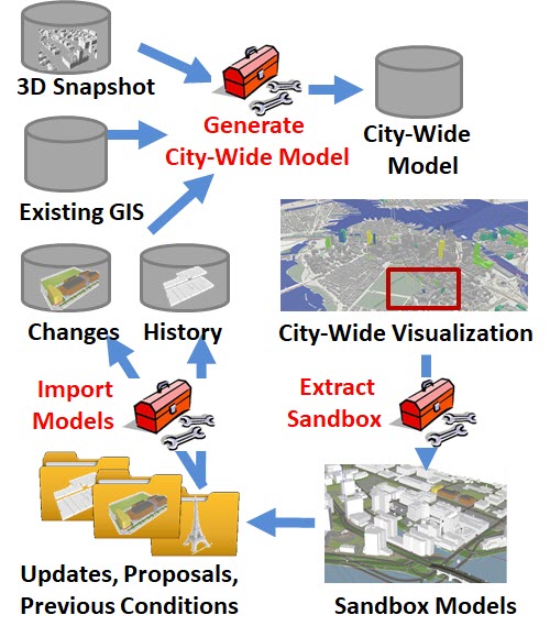
Data Lifecycle in pbcGIS City Model Architecture
Boston Planning and Development Agency launched its city-wide 3d model. pbcGIS developed this model from various sources, and developed turn-key workflows for managing a collection of models for every building in the city, including historic buildings that don't exist any more through buildings that have been proposed, approved, rejected and undr-construction. pbcGIS also developed the tools for tiling the cyty-wide model into 1-kilometer square sketchup models that include detailed terrain, groundp-plan and buildings. This is very similar to the set-up we made for Cambridge, last year. Tomorrow the world!
- View the Boston City-Wide 3d Model in your browser.
- Download our model in many open 3d formats via the pbcGIS tiled download system!
The big idea behind these city-modeling projects is to provide a smoother interface between the world of urban design and development with the data-management culture of municipal GIS. When this succeeds, designers and planners in quickly-developing areas like Boston and Cambridge will have a common-operating-picture of the near-future city that includes projects that are in the design-review pipeline.
2017 Highlights:
- Cambridge Historical Commission Building Files: Digitize, Catalog, Expose, Explore, Preserve. pbcGIS developed an architecture an on-line archive of its collection of 16 file cabinets full of ephemera and official documents about Cambridge Buildings. STand by for phase 2!
- View Studies of a Project in Harvard Square, Massachusetts.
2016 Highlights:
- Cambridge City-Wide 3D Model Downloadable as SketchUp Tiles!
- Handbook for Information Stewardship for Cultural Heritage Preservation: Strategies, Tools and Standards. Funded by the Boston Architectural College and the U.S. Department of State.
- The Rhino Terrain tutorial has been upgraded with new demo dataset, and now a video!
2015 Highlights:
- The Buildout Calculator for SketchUp is now a FREE DOWNLOAD!
- Data Model for a Living 3D Model of the Boston Metropolitan Area Presented at the 2015 ESRI Geodesign Conference.
- Video and 3D webScenes of Boston!
- Introducing City Modeling Services for Municipal Government.
Highlights from 2014
- Four City Engine Workshops conducted for staff from Cambridge, MIT, Harvard and Boston. City Engine Tutorials with sample datasets are now free and open to the world wide web!
- Architecture for a Living City-Wide 3D Model Slides presented at the Northeast ArcInfo User Conference with Jeff Amero, GIS Director of the City of Cambridge.
- Detailed Flood Simulation. Uses a very detailed Cambridge/Boston terrain model and logic that considers the delay of inundation of areas that sit behind higher elevation terrain features. Download this PDF and view it in Actobat to enjoy the animation.
Selected Publications and Presentations on City Modeling and Information Architecture
- 2023: A City-Wide 3D Model for Boston, MA, USA published in Digital Twins for Smart Cities Conceptualisation, challenges and practices; Li Wan and others, 19 April 2023, Emerald Publishing Limited.
- 2010: A Cybernetic View of Studio. Applications of collaborative city modeling explored in a course at the Harvard University Graduate School of Design.
- 2009: Where are Sampson and Goliath? 3D Experiments with the Belfast Skyline. Published in the May 2009 Issue of GeoWorld Magazine.
- 2009: Urban Design Laboratory for Belfast, Northern Ireland . Prepared for Ulster University School of Architecture with Richard Sommer.
- 2008: Adapting the Town of Brookline’s GIS Infrastructure for Managing Three Dimensional Models.
- 2007: Web Services Architecture for CAD GIS and BIM. Open Geospatial Consortium Discussion Paper summarizing the the Fourth Open Web Services Testbed CAD, GIAS and BIM Thread; Architect and Editor, Paul Cote.
- 2006: Understanding Threatened Urban View Corridors with LIDAR Data. Presented at the ESRi User Conference, Palm Springs, California.
- 2005 Practical Framework For a Collaboratively Developed, Multi-Purpose 3D Model of the Metropolis. Presented at Computers and Public Management, University College London.
- 2005 Symposium toward a Virtual City Collaborative in Boston
- 1998 The Metadata Collection Parser Working tools for automated catalog harvester for collections of geographic data.
- 1996 Slides from a presentation on Data Management for Broad-Sacle Landscape Research. With Carl Steinitz, Stephen Ervin and others.
