Spatial Analysis
Conceptualizing a Decision-Making Situation
How to Develop a Question that Might be Addressed Using Data and GIS Procedures
There are many reasons that a person may want to use geographic information systems. For example, GIS can be used to make beautiful art, totrigger a sense of wonder, or even to confuse. While these are perfectly valid uses of GIS, they are not of interest in this course. In the workshops and exercises covered in this web site, one of the ground rules that we set for ourselves is that we want to explore the uses of geographic data and GIS in the context of decision-making situations. According to this rule, a decision-making situation has the follwoing properties:
- It involves tangible, visible, smellable things and conditions, in some spatial relationship with some other set of tangible things and conditions that have been observed, counted or measured in ways that we can describe with data.
- The analyst anticipates some sort of change. The change may either be a proposed intervention, or some other change-inducing phenomena.
- The analyst must make a recommendation regarding the addition, removel/preservation, or modification of some touchable, visible smellable thing or condition in one or more specific places
- The Spatial Relationship that is involved in the first point above must be described in terms of a specific Spatial Mechanism mechanism that connects the first set of things and conditions with the second.
This way of describing problems adds up to a conceptual model that may be used to describe and also to build a data model. The data model may be used to conduct hypothetical or what-if experiments that investigate hypothetical spatial consequences of hypothetical change happening at some location. Being clear about the specific sorts of things and conditions and spatial relationships is the key to being able to evaluate the model in terms of its fitness for use in the specified sort of decision-making situation.
Examples of spatial Mechanisms
Because this a class about Geographic Information Systems, we have to be choosy about the way our questions deal with spatial relationships. If the actual spatial mechanism is not described concretely, then there is no way to evaluate whether our procedures for discovering or modeling associations among things and conditions have any valid comparison with the way that things actually work in the real world. Evaluating the fitness of spatial data and associative operations for modeling real situations usually requires an understanding beyond abstract relationships, like "nearby", "accessible", or "exposed to".
Examples of Conceptual Spatial Mechanisms with Mediating Conditions
- A service facility is added or Removed. This has an effect on accessibility to residents who must walk approximately 500 meters from their homes to the facility on sidewalks. Optional: land use may be an additional mediating condition affecting the feeling of safety or the attractiveness of the walk.
- A bakery is added or removed. This affects the exposure of shoppers to the smell of baked goods wafting across shopping areas within 60 meters down-wind of the bakery.
- A source of contaminated run-off is added or removed in a location. This has an effect on hydrologic features that are down hill from the change. This effect is mediated by the permeability of the land cover in-between.
- To improve the viability of habitat fror a tree-loving species, plantings are proposed to fill-in corridors of connected tree canopy connecting existing open-space preserves.
Common Problems with Vague Descriptions of Spatial Mechanism
- Example 1: it is not enough to use the term "Population with access" without describing the actual means by which access is expected to be realized.
- Example 2: it is not enough to use the term "plants that are exposed to power-plant emissions" without mentioning the means by which these emissions are expected to reach the plant.
- Example 3: It is not sufficient to say that having an orchard "near" a home without explaining more about how the ways that orchards and homes are related.
- Example 4: If your problem is finding a site for a refugee camp, it is not useful to work at the level of a state or county, since a refugee camp is so much smaller than theer arbitrarily constructed districts.
These rules for GIS analytics have been invented because, as a teacher, my challenge is to evaluate student projects. After many years of working at the Harvard Graduate School of Design I have learned that students can spend a lot of time making beautiful, interesting and complex maps, and yet there is no way to tell whether they have learned to do anything useful, or whether they are able to discern a useful application of GIS from one that is useless or even harmful. By sharing this method for evaluating GIS projects, my hope is that students wil learn to apply these critical techniques totheir own projects -- which is the dfirst step toward makng the project better. As a side-effect, the student wil also be more effective in evaluating and offerign constructive criticism of any GGIS project that they may encounter intheri academic or professional endeavors.
What Sorts of Questions can be Addressed Productively with GIS?
The diagram below, lays out several stages in the development and evaluation of GIS models. It is described in more detail on the page, Spatial Models in Decision Support. At the top-center of the diagram sits the impulse that for all GIS analyses is a question, that is developed as a conceptual model. The idea of a conceptual model is short-hand for the description of Things, Conditions and Relationships, mentioned in the bullet list, above..
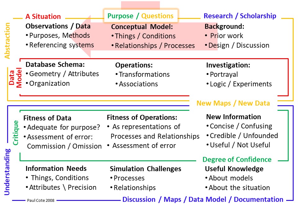
Understanding any map, or GIS application or project requires a clear description of the question, and the purpose of the project. Without these, how can anyone understand whether anything useful can be learned form data, maps and GIS tools? The ability to formulate a claer question in terms of actual real world things, conditions that may be represented with data, is central to the evaluation of any dececision-making situation. And as important -- since this is a GIS Course -- it is as important to be able to describe a situation that involves a spatial mechanism. It is pointless to present an analysis or recommendation without a clear statement of the question.
While many folks understand that learning GIS is about learning how to use software, the challenge of formulating questions, and evaluating GIS applications is almost as difficult as the software and data issues. But considering that many GIS applications that are developed in the context of a school project are not actually very solid, in terms of practical decision-support, the most important skill that one should take away form the experience, is a mindset for understanding the weak points in analysis, whether these be in the data, or simulation challenges, and having a clear idea of how any analysis could be improved.
The slide-show below provide some ideas for describing two common types of spatial decision-making situations: Accessibility Models and Exposure Models. There are certainly other types of models, which I may add examples of later. It is useful to look at Exposure and Accessibility models, especially since they involve an unlimited number of spatial mechanisms. Furthermore, in these spatial mechanisms, there is almost always some sort of mediating condition to consider. Describing mediating conditions is a good way to compare realtionships that you simulate with the way that things may be expected to work in real-world situations.
Click the < and > signs to loop through a slide show with diagrams describing the problems
Describe Hypothetical Situations
It can be very handy to take a hypothetical approach to describing situations when exploring the potential of GIS applications. Especially in an academic setting, the situations that you will be talking about are fictitious and intended as examples. The hypothetical mode is a very useful sort of fiction in the world of modeling. Being hypothetical allows the analyst be very concise -- free to leave out details that are not relevant to the things. This mode of describing models is also a very good way to distill the aspects of the situation that the GIS model would be concerned with, and thereby to impress your audience with the fact that you are clear about what you are trying to do.
Guidelines for a hypothetical Map Caption and Diagram
A discussion of a type of situation (hypothetical) that could be happening in this place (area coverd by your map.) The description includes just the hypothetical relevant facts to convey what changes to touchable, smellable, visible things are being contemplated and the things and conditions involved in an actual real-world mechanism of exposure of accessibility in this actual place. This paragraph describes the labeled diagrammatic indicators on the map. When data are being investigated, these locations reflect the values of observations or whatever extrapolated values that are indicated by the data for specific points, lines polygons or raster cells.
Data-Driven Questions: The problem of figuring out if there are any aspects of a situation that might be addressed using geographic data and GIS procedures goes hand in hand with understanding what geographic data are available and the fitness of a particular data-set as a representation of the things and conditions in question. These questions are discussed in more detail on the page, Describing and Evaluating Data in Decision-Making Context.
Credible Degree of Confidence / Humility:
It may be useful to briefly mention one or two of the most substantial things , conditions and relationships that are not being represented, while you are also making it clear that your aim is to illuminate a narrow, spatial facet of the full decision-making problem.
Stay Away from Data Visualization Theatre: An analyst should not be discouraged by the fact that even the narrow aspect of a situation that may be modeled, cannot actually be modeled well enough for decision-making purposes. So long as she or he have done a decent job of describing the the modeling intention and identifying the specific elements of data or procedures that might be necessary to do a good job. Pretending that you have Solved the problem can lead to consequenses that may be worse than momentarily embarrassing.